In this era of information and technological advancements, data is on our fingertips as we have no time to waste to access the most reliable data and we get instant access to information through internet and other media. Geographic Information System (GIS) enables easy and quick access to various kinds of data to professionals, researchers, administrators and the general public. Enhanced paper records in association with GIS services increases the effectiveness and efficiency which results in higher levels of data authenticity.
When Dubuisson coined the term Geomatics in 1969 merging the terms geodesy and geoinformatics, he intended to use the techniques in remote sensing, land survey, cartography or geospatial mapping, GIS, GPS, photogrammetry, geography and all the related forms of mapping the earth in general.
Geographical Information System (GIS) is an emergent tool in the present day environment which has the prowess in organizing complex spatial attributes in distinct tabular relation. This powerful information system is used to develop accurate and convenient digital spatial database which includes the derived data sets from very precise navigational and imaging satellites or aircrafts, from the digitization of maps and other transactional databases. Our limited mental calculations cannot restrict the absolute potential of GIS.
In the recent years, there has been a growing demand for the storage, analysis and showcasing of complex and enormous data to be incorporated in the Geographic Information System. This leads in efficient handling of massive data and also for the analysis and transfer of geographic information across the globe. In the present time, there are many geospatial networks which share geospatial data sets with data linked to specific geographical references.
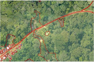
geospatial mapping
The visible and sudden growth and of GIS services in the 20th century has been brought up by the innovative upsurge in the technological realms, computer hardware and software, advancements in computer science and engineering along with the potential rise of latest remote sensing technologies in space observation. In general terms, remote sensing refers to the activities of recording or closely observing and registering or sensing objects or natural events at remote or distant places. Remote sensing can be termed as the science that deals with the derivation of specific information about an object by using sensors without physically contacting the object in observation. Hence we can say that remote sensing differs from in situ sensing of objects without physically touching the objects of measurement. Remote sensing becomes very important branch of GIS services.
Another useful aspect of GIS is Image Georeferencing, which is the process of assigning proper geographic information to a particular image to match a particular size and position. Locating or pinning an image in the world facilitates the determination of the information of the features like location, size and distance of that specific locale. Many GIS services outsourcing companies in India are capable of processing such imagery to multiple levels as per the requirements of the clients.
 |
| photogrammetry |
SBL Geomatics, the GIS wing of SBL, which plays a major role in the GIS outsourcing services in India, provides a accurate and customized leading-edge GIS solutions for the retrieval, projection, transformation and analysis of both spatial and non-spatial data which allows the users to manage and manipulate location wise co-ordianates and thematic attributes of data and produce necessary reports and this makes geospatial mapping easier. SBL Geomatics offers an array of GIS services that helps its clients to benefit in the planning, generatin and dexterous implementation of prospective GIS services.


No comments:
Post a Comment